Medicine Lake and Maligne Canyon

Canyon100
On our return from Maligne Lake to Jasper, we stopped by at the Medicine Lake.  A geological wonder, Medicine Lake is perhaps best described as a sinking lake.  In summer, the lake fills more quickly than it can drain away.  The glacier melt waters flood the lake in summer, sometimes overflowing it and the body of water appears deep and expansive.  In fall and winter the lake disappears, becoming a mudflat with scattered pools of water connected by a stream.

Where then does the water go?

‘Out through the bottom’ like a bathtub without a plug. The Maligne River pours into the lake from the South and the lake waters drain out through sinkholes in the bottom. The water then streams through a cave system formed in the slightly soluble limestone rock, surfacing again in the area of Maligne Canyon 16 km downstream. This is one of the largest known sinking lakes in the Western Hemisphere and may be the largest inaccessible cave system anywhere in the world.

Summer melt water coming into the lake exceeds the amount the sinkholes can drain.  Decreased melt water in the late summer and fall means that the lake’s sinkholes can drain the lake faster than what the Maligne River can fill.  This creates the disappearing lake phenomena.

This natural phenomenon bewildered Aboriginals and other early visitors.  They found no apparent water outlet, but the lake sank in winters.  Many in the early days attributed it to some spirits or demons sucking away the water in winter.  Aboriginal people called the lake Medicine Lake because of its seemingly magical powers and the United Nations declared the Rocky Mountain Parks a World Heritage Site partly because of this unique drainage system.

Wolves in the region have figured out how to make it work for them.  They have been known to chase caribou into the muck so they get slowed down or stuck.

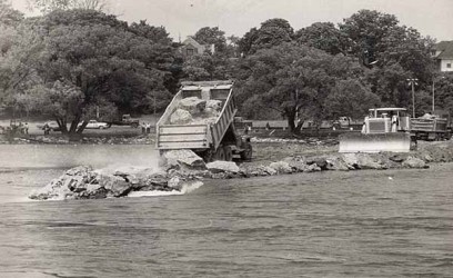
Prior to the construction of the road around Medicine Lake, the irregular water levels made it difficult to get visitors to Maligne Lake.  Shallow bottomed boats were employed, but they ran aground on sandbars or capsized in strong winds prevalent in the area.  In an attempt to establish higher water levels, in 1930’s, the park superintendent ordered that old magazines and mattresses be thrown into the lake to plug the drainage holes and allow the lake to fill.  The scheme failed to work,  and no one ever tried such tricks to fool mother nature ever after. 

The park officials even suggested building a dam to close the sinkholes to stem the outflow of water.  It was also given up as they realised that the sinkholes were immense and needed many truckloads of soil to fill them up.  It was in 1956 after Jean Corbel, a French scientist who concluded that a sinking river system had been created much before the last ice age. 

These cave systems till date remain the largest inaccessible cave system in the world. In case someone attempts to go down through them, they will surely find the old magazines to read when bored.

After leaving Medicine Lake, we drove down to Maligne Canyon.  The Jasper Parks have created a trail for the tourists to hike and follow the canyon as it flows down on its way to the Athabasca River which further drains into the Arctic Ocean.

Canyon200
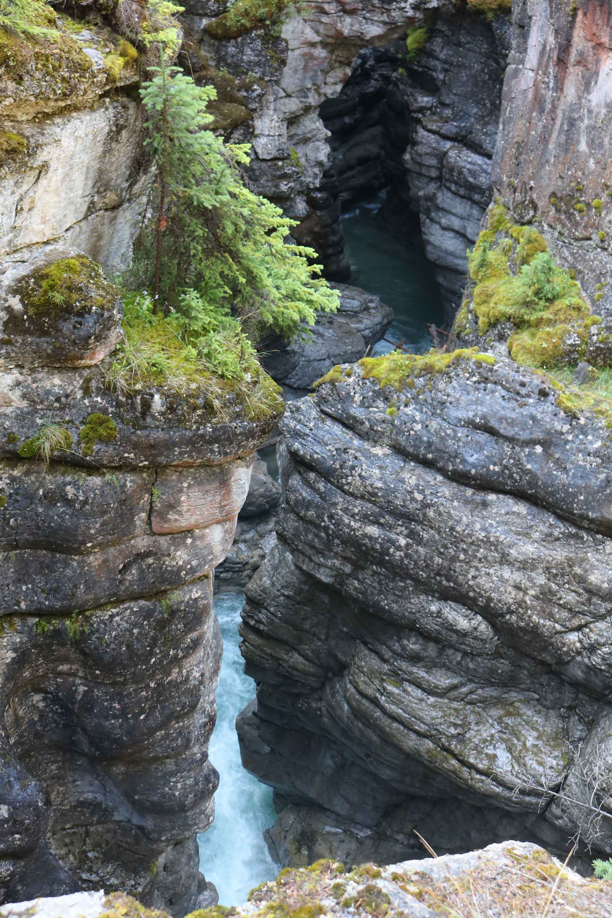
The Maligne River after draining into the Medicine Lake seem to disappear and then re-emerge 16 km  downstream near Maligne Canyon. Some geologists speculate that parts of the canyon were originally deep caves that have since been uncovered by glacial scraping and water erosion. This scraping of the caves lead to the canyons being narrow at the top and wider down below.

Canyon300

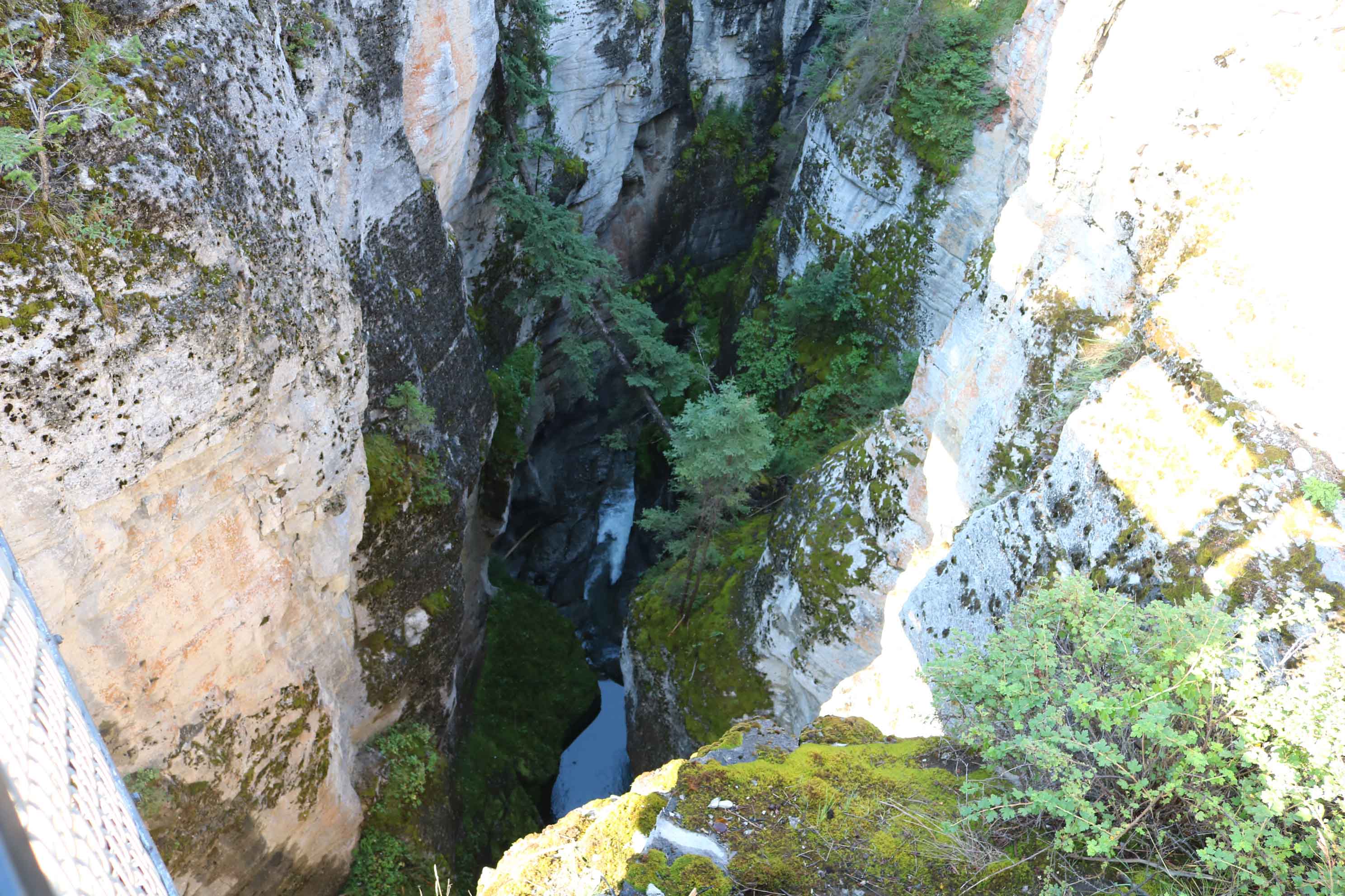
Before the last ice age ended 14,000 years ago, the Maligne Valley was buried under a glacier about a kilometre thick. Glaciers moved  and the heavy ice and rock at the bottom of the glacier eroded the valley floor until it broke into the cave, later tearing the roof away. The glacial ice invaded the passage, grinding much of it away until the climate warmed and the remaining ice melted away. What was left –the geologists theorise  was the Maligne Canyon.

Canyon400
Another interesting thing about the Maligne Canyon is that more water appears to flow out of the gorge than flows in at the ground’s surface. Most of the water in the canyon area flows underground through a cave system, 30 km long, that carries it from Medicine Lake 14 km away to Maligne Canyon’s many springs.

The underground system is extensive and during the 1970s researchers used a biodegradable dye to determine the underground river’s extent. The dye showed up in many of the lakes and rivers in the area and it became clear that the underground system was one of the most extensive in the world.

Canyon500
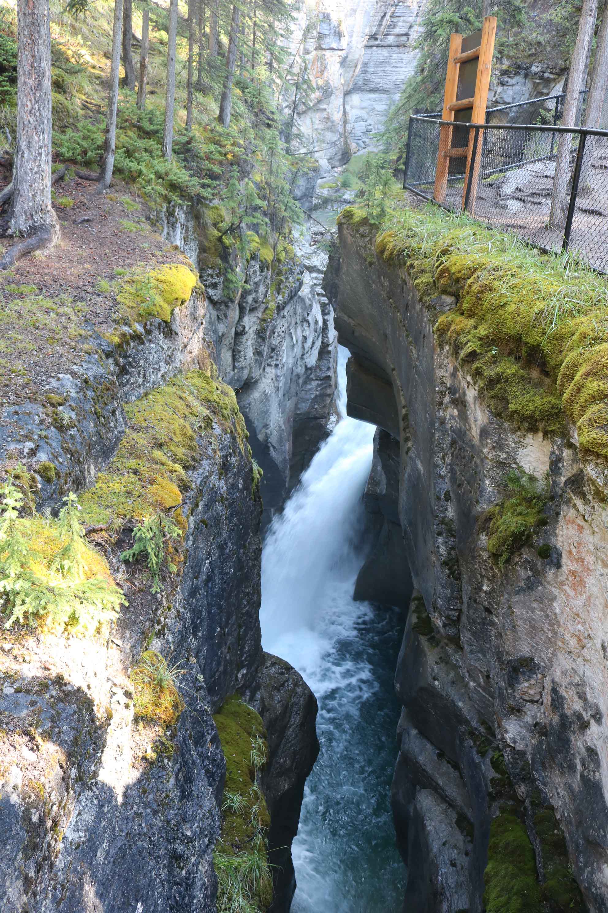
Walking on the trails along the canyon was awe-inspiring.  The gorges were breathtaking, with its rushing waters and steep walls. In some places the walls narrowed, forcing the large volume of water through a series of rapids. The areas of the gorges are fenced off, as a fall here could prove fatal.

These geological wonders are one of its kind in the world and are always worth a visit.

Silencing the Roar of the Niagara Falls

NiagaraScilence11(Image Courtesy Google Maps)

Niagara Falls is the aggregate name for three waterfalls that structure the Southern end of the Niagara Gorge; the Horseshoe Falls on the Canadian side and the American Falls which includes the Bridal Veil Falls, on the American side.

Niagara Falls is over 12,000 years old and were formed at the end of the last Ice Age, when the melting glaciers formed the Great Lakes. Water from Lake Erie at an elevation of 175m above sea level, flowed downhill towards Lake Ontario which is at an elevation of 75m. While the water rushed from one lake to another, the Niagara River, about 58 km in length; was carved out. At one point, the river had to rush over a large cliff (the Niagara Escarpment). As the falls eroded over time, the Niagara Gorge of about 11 km from where the falls were initially formed.

About 800 years ago, only one fall existed. Due to erosion, Goat Island got carved out, separating the flow of the Niagara River into two channels. The larger channel formed the Horseshoe Falls and carried 90% of the water and the smaller channel, now known as the American channel carried 10%. Please click here to read more about the Niagara Falls.

The New York State Parks have now proposed to shutdown the American Falls for nine months to replace the two 115-year-old pedestrian stone bridges that connect the mainland to Green Island and Green Island to Goat Island and also to repair a concrete bridge that connect the mainland to Goat Island. The State has placed two proposals for the impending task.

The first is a two-year construction which would divert water from the American Falls for five months in the first year, from August to December. The bridges would be demolished and new piers would be anchored to the bedrock and the water flow would be restored in late December. Construction would continue in the second year with the water flowing over the Falls.

The second option is an accelerated one year construction, where in water would be diverted from the American Falls for nine months, April through December. It would affect the entire summer tourism season and require 24-hour-a-day construction.

NiagaraScilence22

Earlier from 12 June 1969, The flow over the American Falls was stopped completely by the US Army Corp of Engineers. It was to remove the large amount of loose rock from the base of the falls to enhance its appearance. When the Falls were shut off, it attracted a drove of tourists. In case the event repeats, tourists from the world over are sure to congregate at the Niagara Falls and the social media would be filled with images and videos of the spectacle.

The erosion of the American Falls resulted in major rock falls in 1931 and 1954 had dumped heavy boulders at the base of the Falls. It was felt that further erosion of the American Falls would result in more rock falls and ultimate death of the American Falls. The Horseshoe Falls is yet to experience such major rock falls.

With a view to save the American Falls, the Army Engineers contracted Albert Elia Construction Company to construct and remove a cofferdam to stop the water flow in the American Channel. In addition, they were required to clean the surface of the river bed and remove loose rock from the face of the Falls. A cofferdam is a temporary barrage built within across a body of water to divert the water or to allow the enclosed area to be pumped out, creating a dry work environment for the major work to proceed.

NiagaraScilence33

Construction of the cofferdam began at midnight of 09-10 June 1969 and was completed by 2:40 AM on 12 June. It took 1,264 truckloads, consisting of 27,800 tons of rock and earth, to stop the flow. As the water flow sopped, a fence was erected to prevent onlooker from falling into the gorge.

As the Falls dried, the Niagara Police recovered the remains of a man, a woman and the carcass of a deer amongst the rocks. Closing of the American Channel resulted in heavier flow into the Horseshoe Falls. The boulders deposited at the base of the American Falls was estimated by Army Engineers at 358,000 tons, reaching 41m high in places, reducing the water fall from 30m to a mere 14m.

After studying the rock-falls at the American Falls, the International Joint Commission of the US and Canada came to five conclusions:-

  1. While it is technically feasible to remove the boulders collected at the base of the American Falls, it is not desirable to do so at the present time.
  2. While structural solutions are available to arrest erosion at the crest of the American Falls, the Falls should not be stabilized by artificial means.
  3. A broad environmental study should be jointly carried out by Canada and the US to identify and give priority to those measures which best enhance the total setting and beauty of the Niagara Falls area.
  4. The two flanks of the American Falls and the Goat Island flank of the Horseshoe Falls are sufficiently stable to warrant remedial action.
  5. A statistically minor element of risk from unpredictable rock movement will remain and must be accepted by the viewing public.

On 25 November, 1969 at 10:05 AM a drag-line lifted out the first scoops of earth and rock from the 180m long cofferdam that had been in place since 12 June. There was a little ceremony to mark the beginning of the return to normalcy. David Kennis, age 11, symbolising the next generation, pulled a cord which operated a horn. The blast from the horn signaled the drag-line operator to begin work. By 10:43 AM, the first trickle of water flowed through the dam. The first gush of muddy water spurted through the dam at 11:05 AM, but it was mid afternoon before water once again plunged over the falls. About 2,650 people watched from various vantage points with cameras and newsreels as workers began removing the dam. By the evening of 25 November 1969, the roar of Niagara returned to normal.

In case the water flow of the American Falls is stopped, it would be a breathtaking sight and a spectacle not to be missed, likely to be in 2019 if federal, state or private funding is found right away.